Crop Analytics for Institutions
Our Crop Analytics for institutions delivers time series of satellite vegetation maps.
Key features
- Cutting-edge analytics
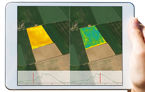
Our Crop Analytics time series of biophysical parameters go much beyond green vegetation, providing results that are fully comparable over time and geographies.
(Avoid false diagnoses and detect anomalies quicker)
- Advanced processing for increased revisit over your land parcels
Thanks to unrivalled geometric corrections (Sentinel and Landsat images are registered on OneAtlas Basemap) and atmospheric corrections providing the most accurate de-hazing, our Crop Analytics retrieves more pixels and improves the revisit over any land parcel.
(Limit the risk of missing a key crop stage in your diagnosis)
- All-in-one API
100% cloud-based, our crop analytics automatically ingests Sentinel-2, Landsat-8 but also high and very high resolution optical imagery, masks clouds, calculates biophysical parameters and clips all results to each field in a single process.
- Easy to access
Rely on cutting-edge and cost-efficient image processing, easily plugged to any system